The Samish Indian Nation has received many calls from March’s Point area residents with questions about the expanded Reservation boundary that the Swinomish Indian Tribal Community (SITC) is claiming is their real reservation boundary under the Point Elliott Treaty. We want to share with the public at large our understanding of the actual history and actual legal reservation boundary for Swinomish Reservation. That boundary is the current boundary of the Reservation that we all recognize and acknowledge – the boundary as confirmed by the President of the United States in an Executive Order dated September 9, 1873. Our research does not support the Swinomish claims for an expanded boundary that includes March’s Point. This includes at least four federal court cases that have ruled against Swinomish on this issue. To show that our position is the only reasonable and legal position on this issue, we include the following maps and evidence for your information and review:
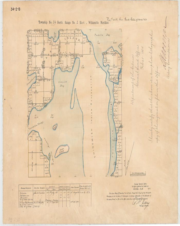
- Map 1: Historic survey map by the Surveyor General’s Office of the Washington Territory in 1871, part of the General Land Office of the Department of the Interior, drawing and defining the northern boundary of the Swinomish Reservation where it is now.

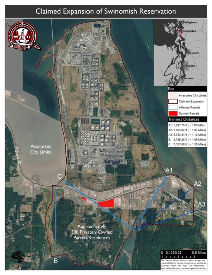
- Map 2: Map showing where the legal isthmus is between the Swinomish Peninsula and the rest of Fidalgo Island, outlining the distances between various locations in the area; generated by the Samish Indian Nation GIS Database Analyst. This “isthmus” is the legal boundary of the Swinomish Reservation as defined in the 1855 Point Elliott Treaty (treaty defines the Swinomish Reservation as the “peninsula at the southeastern end of [Fidalgo] Island; dictionary definition of peninsula states that an isthmus connects a peninsula to the rest of an island; isthmus is defined as the narrowest neck of land between the two land areas).

1. Article 2 of the 1855 Point Elliott Treaty defines the Reservation to be established on Fidalgo (Perry’s) Island as follows: “There is, however, reserved for the present use and occupation of the said tribes and bands the following tracts of land, viz: . . the peninsula at the southeastern end of Perry’s (Fidalgo) Island, called Sháis-quihl . . . “.
2. Article 2 of the Point Elliott Treaty also states that this tract “shall be set apart, and so far as necessary surveyed and marked out for their exclusive use . . . ”
3. The northern boundary of what came to be called the Swinomish Reservation was uncertain. Every federal Indian agent, including T.I. McKenny, the Washington Indian Superintendent whose map the Swinomish Indian Tribal Community (SITC) relies upon in its argument that its treaty reservation includes March’s Point, stated that the boundary line was uncertain and causing controversy, and needed to be surveyed according to the treaty language quoted above. Governor Isaac Stevens specifically wrote to Commissioner of Indian Affairs George Manypenny on May 5, 1856, and stated: “All the Treaties provide for the Surveys of the reservations and estimates are provided accordingly.”
4. The October 14, 1871 Survey map attached is the survey specifically called for by the Treaty and Governor Stevens to fix the northern boundary of the Swinomish Reservation. Only the northern boundary of the Reservation was uncertain and needed to be surveyed. This 1871 survey was referenced and incorporated into every subsequent survey of the area, for example, 1874 and 1884 surveys conducted of the Swinomish Reservation in preparation for allotting the Reservation to individual Indians residing on that reservation.
5. Superintendent McKenny, the federal employee relied upon by Swinomish, acknowledged this geographic definition on March 28, 1869, when he instructed Sub-Agent Hale to go to the Swinomish Reservation and publicly post notices all around the reservation stating the following: “The Swinomish Reservation, according to the Treaty includes all the south east peninsula of Perry or Fidalgo Island. The peninsula commencing at the narrowest place in the neck of land joining the main Island. A boundary so distinctly identified cannot be mistaken.” These notices were not posted on the March’s Point part of Fidalgo Island.
6. As the second – GIS – map shows, the narrowest neck of land between the Swinomish Peninsula and the rest of Fidalgo Island is the stretch of land between Turner’s Bay and Padilla Bay. The shortest distance is 5298 feet. The boundary line claimed by Swinomish is 5729 feet, almost 500 feet further.
7. The map on which Swinomish relies was created by or for Superintendent McKenny for the Deere trespass trial on March 10, 1871. Superintendent McKenny had never visited the Swinomish Reservation before creating the map and had no personal knowledge of the area. The map is wildly inaccurate and was not based on any survey. It inaccurately shows the stretch of land from Similk Bay to Fidalgo Bay (through the golf course) as much shorter than the distance between Turner’s Bay and Padilla Bay.
8. McKenny was a lower level BIA employee and there is no indication that McKenny’s view – that his map reflected Governor Steven’s intent – was ever accepted officially by the Department of Interior. In fact, in his October 1, 1872 letter quoted above to the Commissioner of Indian Affairs, McKenny twice urged that his view of the boundary line and map was the correct view and urged his superiors to adopt it but this position was expressly rejected by the Department of Interior in recommending the boundary line shown in the 1871 survey map, which was then confirmed by Presidential Executive Order.
9. After the 1871 survey was completed, Superintendent McKenny admitted that the neck of land between Turner’s Bay and Padilla Bay was the narrowest stretch of land between the Swinomish Peninsula and the rest of Fidalgo Island: “Swinomish Reservation. This reservation is described in the treaty as comprising the south east peninsula or Perry’s or Fidalgo Island. . . A survey has been lately made which describes a bay never before shown running far up into the island – (see accompanying marked “A”) and it is contended that this is the narrowest point and that the initial point should be taken from the head of this bay.” Letter dated Oct. 1, 1872 from Superintendent McKenny to Commissioner of Indian Affairs. Superintendent McKenny asked the Commissioner of Indian Affairs to resolve the discrepancy between the survey map and the map created the previous year by McKenny that Swinomish is now relying on, and the 1873 Executive Order confirming the treaty boundaries of the Swinomish Reservation was issued as a result.
10. There are five federal (and territorial) court decisions which have specifically rejected Swinomish’s claims to March’s Point as part of its treaty reservation. The SITC is legally foreclosed from arguing to the contrary now. Swinomish’s position on its treaty reservation has no merit.
Feel free to use the information we have provided in any communication you may want to share regarding the claims by Swinomish Indian Tribal Community that their reservation boundary includes March’s Point. Please also feel free to share copies of any of your written concerns with our Samish Administrative Office or contact the General Manager, Leslie Eastwood for more information.
Sincerely,
Thomas D. Wooten
Chairman